TRONA PINNACLES NATIONAL NATURAL LANDMARK
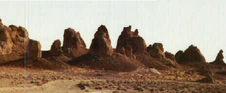
Views of the Trona Pinnacles
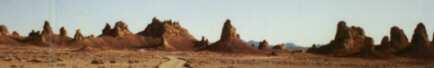
As the level in Searles Lake began falling at the end of this era, the minerals in the water, a major component of which was sodium carbonate, began to concentrate. Concentrating the minerals also made the water denser. At the same time as the lake level was falling, ground water that had been help up by the high lake levels began slowly moving beneath Searles Lake from land to the south and west. In the area of the Pinnacles there were long fractures penetrating the clays forming the bottom of the lake. These allowed the ground water to bubble up through the lake waters. Much of the ground water beneath the Pinnacles was high in hardness, principally soluble calcium salts, and still is today although it no longer flows to the surface. When the high calcium water bubbled up through the lake water that had been enriched in sodium carbonate, calcium carbonate (more commonly known as limestone or calcite) precipitated. This formed the tufa towers we now call the Pinnacles. If you look closely, you can see the paths that the ground water took as it bubbled up through the pinnacles.
For an Area Description, Directions on How to Get There, and Considerations in Planning Your Visit, see the BLM Web Page on the Pinnacles .
Go to Local
Areas of Interest
![]()
| Home | Site Map | GEM-O-RAMA Site Map | Revised 04/24/2004
All contents of this web page are the property of the
Searles Lake Gem & Mineral Society.
Reproduction or other uses of any of these contents
without the written permission of the owner is prohibited.
If you want to use any of the contents, contact the
SLG&MS at any of the above.